Grizzly Bear Movement in Alberta
2023
Least Cost Path
Wildlife Corridors
GIS Analysis
ArcGIS Pro
QGIS
GDAL
40%
Land Cover Weight
40%
Road Proximity Weight
20%
Slope Weight
3
Environmental Variables

Objective
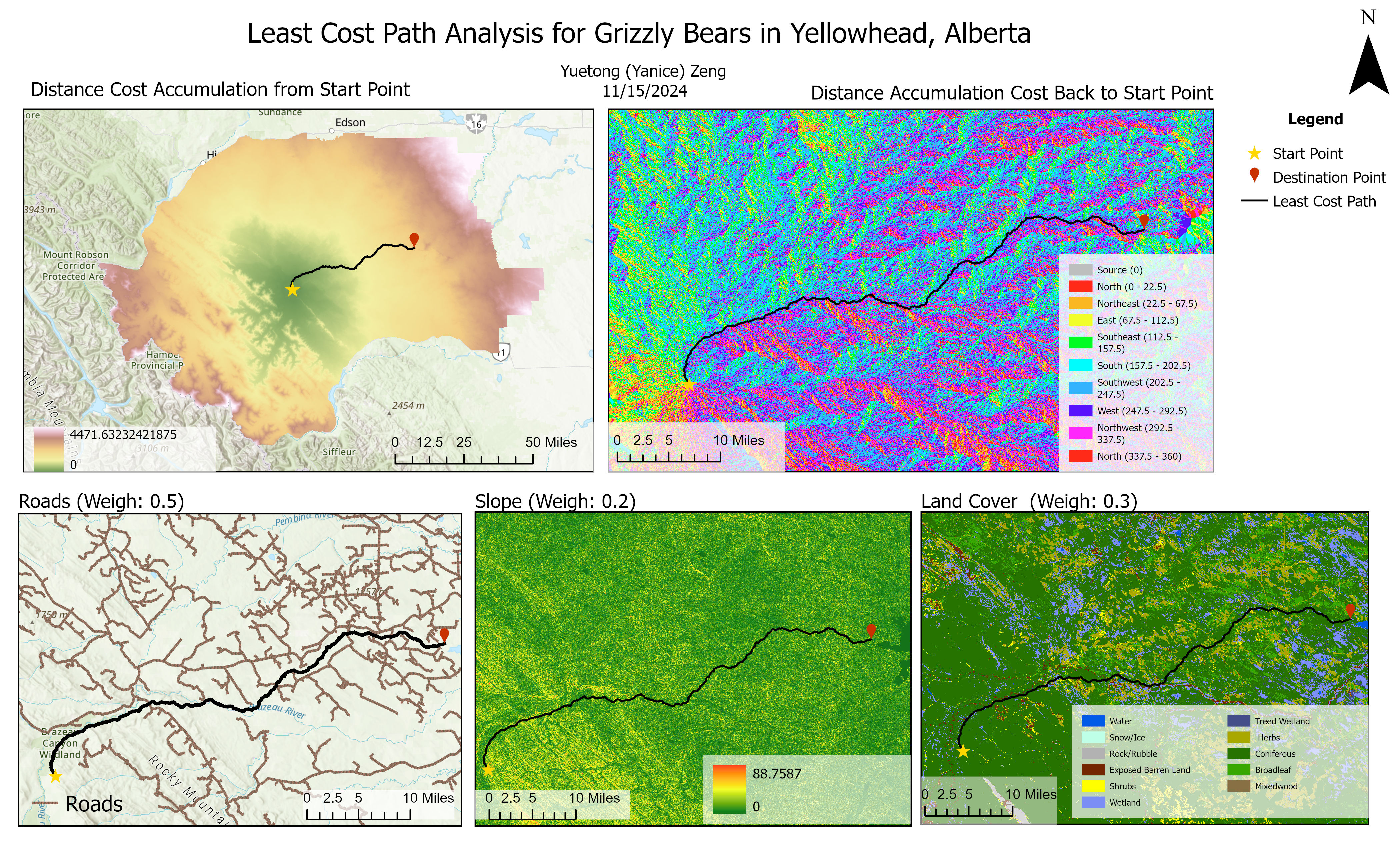
Model optimal wildlife corridors for grizzly bears in Alberta using least cost path analysis to support conservation planning and wildlife management strategies.
Methods
- Integrated multiple environmental variables into a comprehensive cost surface:
- Land cover (40% weight) - prioritizing forest cover and natural areas
- Road proximity (40% weight) - accounting for barrier effects and mortality risk
- Slope (20% weight) - considering energy expenditure in movement
- Processed and prepared spatial data using ArcGIS Pro, QGIS, and GDAL
- Applied a weighted overlay approach to combine cost factors
- Calculated optimal movement paths between key habitat patches
- Verified results with field observations and existing research
Technical Highlights
# Example of cost distance calculation in Python with GDAL
import gdal
import numpy as np
from skimage.graph import route_through_array

def calculate_least_cost_path(cost_surface, start_point, end_point):
    """Calculate the least cost path through a cost surface."""
    # Read cost surface raster
    ds = gdal.Open(cost_surface)
    band = ds.GetRasterBand(1)
    array = band.ReadAsArray()

    # Get geotransform information
    geotransform = ds.GetGeoTransform()

    # Convert geographic coordinates to array indices
    start_idx = (
        int((start_point[0] - geotransform[0]) / geotransform[1]),
        int((start_point[1] - geotransform[3]) / geotransform[5])
    )
    end_idx = (
        int((end_point[0] - geotransform[0]) / geotransform[1]),
        int((end_point[1] - geotransform[3]) / geotransform[5])
    )

    # Calculate least cost path
    indices, weight = route_through_array(
        array, start_idx, end_idx,
        fully_connected=True
    )

    return indices, weight
Outcomes
- Identified optimal movement corridors connecting key habitat patches
- Highlighted critical pinch points where corridors narrow due to natural or human barriers
- Revealed areas where infrastructure development could threaten connectivity
- Provided decision support for conservation planning and land management
- Created detailed corridor maps for stakeholder engagement
Key Findings
The analysis revealed several important insights for grizzly bear conservation in Alberta:
- Forest cover is the most critical factor determining movement routes
- Highway 1 represents a significant barrier to north-south movement
- Riparian corridors serve as important movement pathways
- Several existing protected areas are not well connected for bear movement
- Strategic land protection could significantly improve habitat connectivity
Significance
This project contributes to wildlife conservation by providing evidence-based planning tools for habitat connectivity. The identified corridors can inform land use decisions, highway crossing structure placement, and protected area designation. The methodology also demonstrates the value of integrating multiple environmental factors in movement modeling, offering a more nuanced understanding of wildlife mobility in complex landscapes.